I have felt privileged to have been involved in so many aspects of life and work in PNG and my first blog on the subject didn’t do it complete justice. So, this is a further attempt at showing a little more of both life and work in a country that is so very different to my own.
Some Treasured Souvenirs
Carving is a skill in PNG that results in the production of many interesting and unique artifacts, that are still in my collection, such as this one of a successful hunter. To truly understand this piece of art, it needs to be said that Papua New Guineans have a well-entrenched and deeply justified fear of crocodiles. Thus, a truly great and fearless hunter is one who can catch not just one of them, but two.
And, yes, craftsmen in PNG carve every detail, albeit some details being larger than others. But that, too, can be interpreted as a sign of success, when such symbols are considered necessary. Who could argue that such a symbol of success is appropriate for a very successful hunter?

A collection of PNG artefacts is incomplete without a carving of the National symbol, the Bird of Paradise on a Kundu drum and spear. Such a collection would likewise be incomplete without a well carved representation of the Puk-puk (crocodile). This particular example features a holder that could be used for a coffee pot as the centrepiece of a table – in this case, it holds a couple of carved Frogs, as I had nowhere else to put them at the time.

Face masks are also a traditional favourite for the PNG craftsmen to create. These artefacts have a very long history in the culture of PNG and can be used for celebrations or to show bravery and/or to create fear in an opponent.

Memories of Fane, Goilala District, Central Province
I remember Fane most fondly because of one day, back around 1985 or so, when the Priest informed me that he’d prayed very hard for me on the previous day, during a take-off that – although successful – created a need to change clothes! I guess the Priest didn’t know that I’m not a believer but, when push comes to shove, every bit of help is useful.
This is the Father’s House, right on the aircraft parking bay at the top of the strip.

This is part of the village and gardens at Fane and the gardens produce every kind of fruit and vegetable known to mankind. They also had their own small coffee plantation as well as a small farm of goats, pigs and chickens, so they were quite self-sufficient.

The Swiss Priest with some of the younger local parishioners.

The church stood on an embankment above the western side of the small aircraft parking bay.

Another exterior view of the church, showing its proximity to the airstrip and the Father’s House.

An interior view of this fine old church building, showing the detail that confirmed the solid nature of construction using materials that were locally available.

The Church entrance was on the southern side of the building, closest to the Father’s House. This is a view looking toward the northern end of the structure. There were n seats so parishioners either stood or sat on the polished wooden floor.

I’ve used the past tense to talk about the Church building because it was totally destroyed by fire somewhere around 1990. All that remains is vacant ground to the north of the Church bell tower, which was always a separate structure from the Church building.

Memories of Other Places Around PNG
In the 22 years that I lived in Papua New Guinea, I was fortunate to spend a great deal of time as a “paid tourist”. In a country that had a total number of aerodromes and airstrips that exceeded 500, at one time, I didn’t get to all of them. Indeed, not even the half of them, but many of those that I was able to visit left me with some unique memories.
“Going around” at Hoskins. This involved a fairly sharp turn because of high ground to the north, east and south.
“Going around” at Hoskins. This involved a fairly sharp turn because of high ground to the north, east and south.

Memories of the picturesque islands to the northwest of Kavieng, New Ireland Province.

A brand new passenger terminal was opened around 1991 and it was a big occasion that attracted “big men” and locals alike. It was just a pity that the flags weren’t quite right. The flag of the New Ireland Provincial Government was flying correctly, but the PNG national flag was upside down!

Approaching to land on RWY 14 at Kerema. This broad view clearly shows that the runway points straight at a headland to the southeast. Due to the close proximity of this headland, take-off on RWY 14 requires a fairly sharp turn to the right as soon as safely airborne.

On the apron at Aropa Airport, Kieta, Bougainville Island, in times prior to the rebellion of 1989 that saw the total destruction of the terminal, fuelling facilities and a Britten-Norman Islander operated by BougAir.

All in a row on the apron at Madang, the Provincial Capital of Madang Province. Three F-28s can be seen in this view – one being a Navaid Calibration aircraft from Australia and the other 2 belonging to Air Niugini, the national flag carrier.

I have many great and fond memories of overnight accommodation at the Madang Resort Hotel, owned by Sir Peter Barter. In those days though, he was just Peter Barter, a former missionary pilot who became a very successful entrepreneur and a bloke who championed tourism for PNG.

On the menu, one particularly memorable night, was Mud Crabs from Kavieng. This was a “thank you” from Peter Barter for taking him to Kavieng so that he could look at the Kavieng Hotel, which he was considering adding to his business empire

Memories of an especially fine and sunny day at Mendi, Southern Highlands Province. This view shows the very close location of a substantial ridge to the aerodrome. There were many other days that I visited the place, when the weather was not in such a generous mood.

The old C-90, belonging to the then-named Office of Civil Aviation, being refuelled at Mendi. I’d flown in there, in company with another FOI, Wally Bednar – a bloke for whom I (and many others) have a great deal of respect.

Memories of Misima Island, Milne Bay Province, where I was conducting a flight check of the very first instrument approach procedure for this aerodrome. It was a circling approach because the positioning of the NDB and proximity of high ground conspired to prevent a useful runway-aligned approach. In any event, the runway wasn’t sealed at the time and the general policy of procedure design mitigated against providing a runway-aligned approach in either direction. This view shows the aircraft inbound on final approach and the alignment was almost spot-on. The approach wasn’t used very much, as it had quite a high MDA, due to the requirements of the Missed Approach – a problem that couldn’t be overcome until the advent of procedures based on GPS.

Memories of Moro, Southern Highlands Province, when it was built by Chevron Niugini as an integral part of their oil drilling operations. This view is overhead at about 8,000 feet while assessing an NDB-based approach that was to be used if the DME wasn’t in service. It was quite usual to provide such an alternate approach procedure because the main approach had a completely different alignment and required the DME to be in service. Thus, if the DME failed, that procedure couldn’t be used and the alternative (though not especially good) would be available as long as the NDB stayed in use.

Soon after the basic aerodrome had been constructed, Lockheed L-382 aircraft operated by very well-known Southern Air Transport, began flights into Moro from Nadzab, bringing in all the materials that were needed for the aerodrome, the camp at the aerodrome and the pipeline construction. It was not uncommon to see at least 2 of the 3 L-382s on the apron at Moro at the same time as they shuttled back and forth, making many return flights each day for several months. The pilots of these aircraft were among the first to make use of the NDB/DME approach that I provided for Moro.

Flight-checking the NDB/DME approach to Moro. This approach, as unique then as now, came straight over Lake Kutubu, with alignment along the spit of land that can be seen projecting into the lake as the track heads toward Wasemi Island in the mid-distance. This was a “Cloudbreak” procedure due to the proximity of high terrain all around the aerodrome and, especially, on the eastern side of the lake, on the extended centreline of RWY 09. The runway was long enough to handle a Fokker F28 though only one ever landed there – the unsealed strip was restricted to one-way operation and it was impossible to provide a useful Circling Area for the approach so, once visual, aircraft turned left by some 20 degrees to line up with RWY 27. In the event that a Missed Approach became necessary, the same turn was made for initial climb out.

Memories of Nadzab airport during the time of operations by Southern Air Transport between there and Moro. It was usual to see one aircraft being loaded while another, already loaded, was taxying out for take-off.

And, while one was still loading, another would be taxying in to load up for another trip to Moro.

This was the lay-down area that was specifically built at Nadzab for the L382 operations. This area now serves as a General Aviation apron.

Memories of the one-and-only Air Show to be held at Jackson’s Airport, Port Moresby. This was on the Independence weekend of 1984, a time when this particular end of the airport looked very different to the way it looks these days. This view shows a few of the aircraft operated by the PNG Flight Training Academy, a division of PNG Aviation Services owned by Yorke Mendosa and Doug Valentine. I was the Chief Flying Instructor at the time and had been recruited to establish the school in the wake of the demise of flight training at the South Pacific Aero Club.

Among many participants including the PNG Defence Force, the United States Air Force provided a C-5 Galaxy for the event. It was an instant hit with everyone who came to witness the one time in PNG’s history that an air show was ever held in the country.

Papua New Guineans had never previously seen an aeroplane that opened like this. Many thought it had broken and were, at first, unwilling to step aboard. However, once they saw other people going inside, they were all for it!

Back in 1984, Qantas was flying B-747s from to Port Moresby. They agreed to make a contribution to the air show with their regular service on that day but, as it was a passenger-carrying service, the best they could do was a fairly high fly-by before landing. Still, it was worth it for the many locals who seldom, if ever, saw an aeroplane like that, let alone the C-5 Galaxy.

Paga Point provides a commanding view over Ela Beach and Fairfax Harbour, Port Moresby. It was also a key element in the defence of the city during World War 2. The bunker seen in this view is a continuing reminder of those troubled times.

Koki Village, near the Port Moresby suburb of Badili and not far to the southeast of Ela Beach, is home to many Motuan people. At one time, I made an attempt to learn the Motu language but ended up admitting defeat and sticking with Melanesian Pidgin. Besides, I got myself into enough trouble in the early days of using Melanesian Pidgin without going through a similar ordeal with Motu.

A view of Ela Beach on a very windy Sunday afternoon, at the time of year when weather transitions from the Dry Season to the Wet Season, with strong winds that usually came from the southwest. This view, taken in 1984, shows the beach to be as safe and clean as it actually used to be.

Downtown Boroko, between Jackson’s Airport and Port Moresby. This view was taken at the time when construction had started to provide through-road access and a pedestrian plaza. It was a revolutionary idea at the time but I’m not sure that the result was what was intended.

Gordons Market was the best place in Port Moresby to buy high quality fresh vegetables. It was normal for me to visit there early in the morning for the freshest vegetables. I would use another early morning to visit the Koki Market for their fresh fish, which were usually of very high quality.

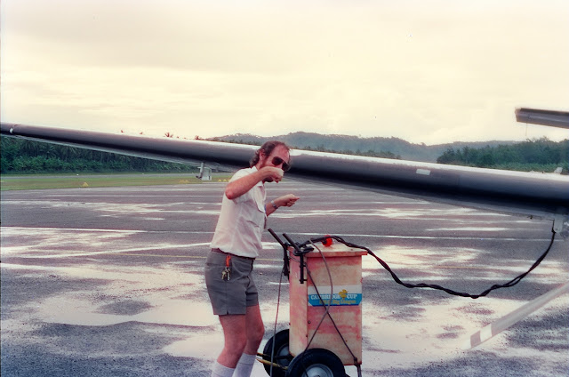
Memories of navaid calibration work at Port Moresby. This is how it was done before miniturisation allowed this work to be done in much smaller and cheaper aircraft, with less than half the crew of this F28. This console was only manned for ILS checks. There was a separate console that handled the VOR, DME and NDB checks.

The business end of the F28 during one of the many ILS calibration runs that were required for an Annual Check.

A member of the calibration crew is seen manning the Laser Tracker that was used for Localiser and Glide Path checks.

Another member of the calibration crew is supervising local navaid technicians in the use of the theodolite for a VOR check. Here, the theodolite is being setup and its position is being checked by reference bearings to several prominent structures around the airport. It was vital to ensure that the theodolite was accurately positioned on the correct setup point before the start of the flight check, as the slightest siting error could result in errors in reporting the radial bearings.

This is the aeroplane that Reg Mason was building in his spare time, in a Douglas Airways hangar. I don’t think he ever finished the job because of the closure of Douglas Airways. I lost track of Reg after I left PNG the first time, at the end of 1991.

This is Reg Mason, working on a wing section of his aeroplane.

Memories of Rabaul, before the dual eruptions of Mount Tavurvur and Mount Vulcan. This is part of the view over Rabaul, its wharves and Simpson Harbour, that could be seen from the location of the former German governor’s residence.

Flying an “obstacle clearance” run during a routine check of the T-VASIS serving RWY 12 at Rabaul. Due to the high terrain, the obstacle clearance plane for this approach was significantly higher than the standard 1.9 degrees. For approaches to RWY 30, Mount Tavurvur effectively blocked a straight-in runway-aligned T-VASIS so the system was placed on one side of the runway only and offset by some 30-40 degrees, to provide approach path guidance over the water, clear of the high ground.

This is what Tokua Airport looked like after it was originally constructed as a hedge against Rabaul Airport being knocked out by volcanic eruption – a threat for which there had long been a great deal of warning. The runway was cut into a coconut plantation some 17 miles southeast of Rabaul. The trees were quite tall and one often experienced significant windshear in the landing phase and after take-off, while the aircraft was still quite close to the ground. That made it a tricky place at the best of times!

This was not the best of times! I’d already attempted to land at Rabaul, only to be forced back by some very ugly weather. I’d been in transit from Kieta to Port Moresby and needed fuel at Rabaul. Typically, the weather information told me nothing of what to expect for my arrival at Rabaul and I was forced to land at Tokua. From there, I summoned a fuel tanker from Rabaul Airport. Having refuelled, after waiting an hour for the tanker to arrive, I found the battery was flat – not a totally unusual occurrence in the C-90 battery that we used at the time. Thus, another delay while waiting for a ground power unit to arrive from Rabaul. I hadn’t been having a very good day that day!
Memories of many visits to Tufi, in Oro province, in the period from 1984 to 1985. The locals were always very friendly and I became good friends with Dave and Meg Witcombe who ran Tufi Fisheries at the time.

Nestled in the always calm waters of one of the many fjords around Tufi, the fishing fleet was almost always back in port by the latter part of each day.

This is a partial view of one of the fjords that could be seen from the Tufi Hotel.

Memories of Woitape in the Goilala District of Central Province. At around 800 metres in length, the airstrip at Woitape was one of the longer one-way strips in PNG. It had quite a gentle upslope in comparison to many others and could get quite boggy after rainfall. The lower third of the runway was totally useless for day or more after heavy rain. These factors conspired with an elevation of around 5,000 feet and a usual density height closer to 7,500 feet than anything else, to make it a place where pilots couldn’t relax until parked.
The strip served the village of Woitape and the Owen Stanley Lodge was just to the north of the aircraft parking area. Many great nights were had at the Owen Stanley Lodge – the proximity of Woitape to Port Moresby made it an ideal venue for escape from Port Moresby, for a dirty weekend.

This scene shows part of the Woitape Village, as well as the high ridges that surround the valley.

Joining me on one of my many overnight stays at the Owen Stanley Lodge were my good friends John and Olive Close. John was a retired teacher who owned a Tiger Month and a V-tail Bonanza. Sadly, he died a year or 2 back but at least it was from natural causes – he was one of the most naturally-gifted pilots I ever met.

Here ends this second part of my reminiscences of Papua New Guinea. I hope that you enjoyed it as much as I as I did in putting it together.
Thankyou for posting the photos. So many good memories of Port Moresby in the 80's as a young boy growing up.
ReplyDeleteThe highlight of my earlier years was the POM airshow. Best day of my life.
Hi .. I also grew up in New Guinea .. Madang and Wewak, which we came to in 1954 when my father was OIC of Air Traffic Control for the Department of Civil Aviation in Madang. We lived in a Hawksley house on what I think is now called Poinciana Avenue and later (on the 2nd stay in Madang) in a larger house close further down the road. 2 questions: is the Madang Resort Hotel where the old hotel used to be, close in to the town centre, or is it closer to the Coastwatcher's Lighthouse? And 2: the air show at Jackson's Field in 1984 .. what was the name of that metal "matting" the two planes are parked on? I do know it but for the life of me I can't remember it!!
ReplyDeleteMadang Resort has it's own website - http://www.madangresort.com/ - and I'm sure you'll find all the information you need there. The home page has an aerial photo showing the extent of the hotel and it's grounds. No, not in town at all and, so far as I know, it's always been on its present site since Sir Peter Barter acquired it.
ReplyDeleteThe matting is Marsden Matting.
Hi Les, My Grandparents, Meg and Dave, are in the photo in front of Tufi fisheries and i was wondering if you had any other photos of them??
ReplyDeleteI had one other photo but haven't been able to locate it, so presume it was lost in my last computer crash. Sorry.
ReplyDeleteThat's all good. I've been doing my Uni History report on their time in Papua New Guinea.
DeleteAfter leaving Tufi, they ran the Owen Stanley Lodge at Woitape for Douglas Airways. I was a frequent visitor there. Give them my regards please.
DeleteI will.
DeleteMeg and Dave are my parents 🙂
DeleteSo that means you are in the photo too... but probably too young to drink beer at that time.
DeleteG'day Les, I am the young blonde boy with Meg and Dave Witcombe. Thankyou very much for a lovely and informative trip down memory lane and to see my parents young again.
ReplyDelete